Guanabo is a town east of Havana, famous for its white, fine-grained sandy beach, visited by thousands of tourists and bathers every year. There are also other places in Cuba known by that name or that had it at some point in time (see table 1). In this paper we analyze the etymology of the word1.
Table 1
Places in Cuba named Guanabo or with the presence of this word in the structure of their names

In order to determine the Island Arawak origin of the selected toponyms, it was found that they are “obscure”, formed, as the researcher and linguist Sergio Valdés Bernal points out, by lexical and grammatical morphemes that we do not know and whose motivation is not evident, characteristics that demonstrate their pre-Hispanic origin2. Also evidence of its Island Arawak origin is the fact that “its morphophonological analysis shows full structural and phonic coincidence with the obscure toponyms of the rest of the country, which evidences a similarity that reveals the same linguistic origin”3.
In the structure of this toponym, the morphemes guana and abo can be distinguished. Regarding the former, in the previous article (Arawak Mysteries in the Spanish Spoken in Cuba: Guana), we showed that in Island Arawak it means ‘land, place’ and that in Lokono it is possible to identify a non-identical cognate in the structure of the word wunabu, ‘(at) the ground’, ‘low’4,5. In this word, wuna has the meanings of ‘ground, earth’ and abo denotes in this case ‘by, on’6.
We will hypothesise that in Island Arawak guanabo also means ‘low’ and can be used to denote a lowland. If the characteristics of the places named guanabo are consistent with this meaning, then we can consider this hypothesis proven.
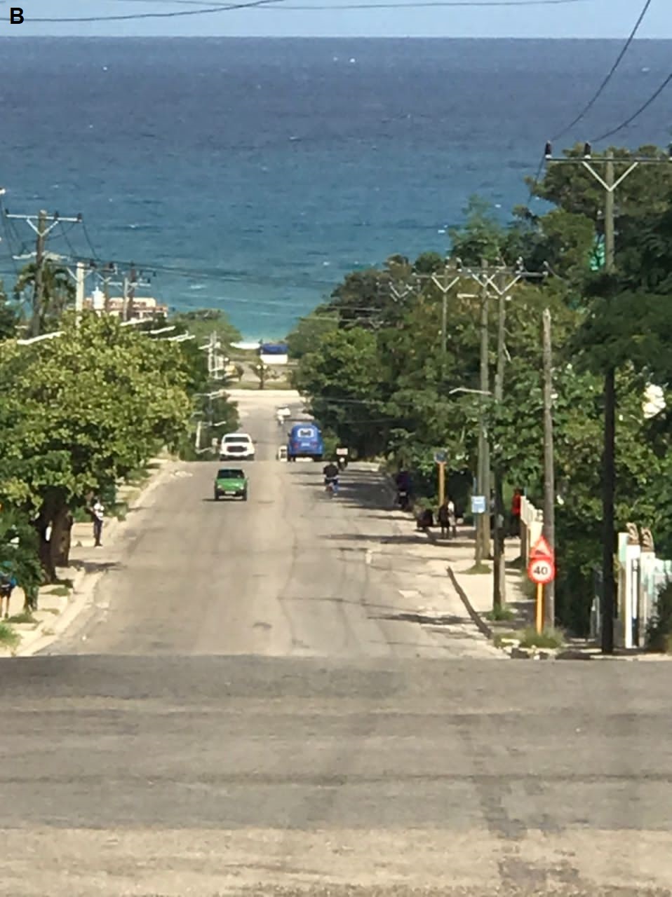
1. Guanabo beach (Figure 1) is located on a surface of marine origin, composed of a coastal plain and several levels of ancient marine terraces with heights between 60 and 70 metres7. To reach the beach from the south, it is necessary to descend a steep slope in some sections. This difference in height is the reason for the Island Arawak name, guanabo, ‘lowland’.
Figure 1
View of the locality of Guanabo

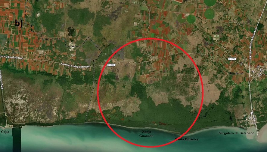
2. The Saint Rita of Guanabo corral was created on 4 April 1576 from a land grant to Gerónimo Rojas Avellaneda. In the document where the grant was registered, in addition to the name of the place, it was only specified that it was a site between the coastal localities of Cajío and Batabanó8, in what is now the province of Artemisa. Other later documents, corresponding to the 17th and 18th centuries, indicate its location with greater precision, pointing out the other farms and corrals with which it adjoined9.
The centre of the corral Saint Rita of Guanabo was located not far from the coast and part of its territory occupied the marshy coastal strip (Figure 2)10, a circumstance that motivates its Island Arawak name guanabo, ‘lowland’.
Although there is not a great difference between the heights of the low, lacustrine-palustrine coastal plain and the adjacent plain that extends further north, this dissimilarity in elevation is associated with different geomorphological, soil, fauna and vegetation characteristics, among others, which turn these regions into totally different ecosystems, with implications for the aboriginal communities in terms of the type of economic activity to be developed, the way of moving around, the way of building houses, the availability of resources of various kinds, etc.
In this regard, the mangrove swamps were common places for aboriginal activities, such as fishing, gathering oysters and other molluscs, hunting for hutia and various other activities. We know that in this swampy strip of land there were Arawak-speaking aboriginal settlements, such as the one visited by Columbus on 10 June 1494, during his second voyage, possibly located in the present-day locality of Guanimar, also on the southern coast of the province of Artemisa.
These differences in ecosystems had to be reflected in the Island Arawak language, in particular in the existence of a word (guanabo) to denote the space occupied by the lacustrine-palustrine plain and the mangroves.
Figure 2
Location of the corral Saint Rita of Guanabo and characteristics of the site

3. In what is now the province of Santi Spíritus, to the south of the town of Jatibonico, near the confluence of the Guanabo and Jatibonico del Sur rivers and where the Felicidad dam, built in the 1990s, is located today, there was another corral called Guanabo (Figure 3). The area where the corral was located is a low region, with a difference in height of about forty metres in relation to the hills located immediately to the south. These characteristics, which facilitated the construction of the dam, were the reason for the Island Arawak name of the place and the river.
Figure 3
Location of the Guanabo corral in Jatibonico, Sancti Spíritus

4. The name Ariguanabo is given to a lagoon, now dried up, and a river, located in the municipality of San Antonio de los Baños in the province of Artemisa, near Havana (Figure 4).
In the structure of the toponym we distinguish the segments ari and guanabo. The meaning of the latter is already known: ‘lowland’. As for the former, it is a well-known Arawak word meaning ‘tooth’ in Lokono15 and which José Juan Arrom has identified with the same meaning in the Island Arawak: manjuarí (name of a fish, Atractosteus tristoechus), from manjúa ‘much’ and ari ‘tooth’ … ‘many-teeth’16.
In addition to ‘tooth’, the linguist of the Dutch University of Lieden, Konrad Rybka, identifies for ari, the following meaning in lokono: ‘a pitchfork formation of branches of a tree’17. This information helps to explain why the morpheme ari can be found in several toponyms naming rivers in Cuba (Ariguanabo, Arimao, Mayarí). Indeed, the common characteristic between a tree branch. a river and a tooth is the forked form they adopt in certain cases. Among the different types of teeth, this shape is most visible in a tusk; in the case of the river, it is the confluence with another watercourse that gives rise to this configuration.
Rybka also classifies the word ari as a “relational noun”, which, in a “Basic Locative Construction”, specifies the part of the “Ground”, with respect to which the “Figure” is located, where the Figure is the entity to be located and the Ground, the entity with respect to which the Figure is located18.
According to Magaz R. and Portela A. H., Ariguanabo was a large lake during the Pleistocene, which was more than 25 km long and 8 km wide. In this tectonic-structural depression there were up to five lacustrine terraces, the lowest being the bed of the Ariguanabo Lagoon and the highest reaching 55 m above the bottom of the depression. The escarpments separating the cumulative lacustrine terraces are visible as extensive, shallow ramps (Figure 4a). These authors also point out that the lower terrace has been part of the lagoon bed during the Holocene and its surface has been episodically flooded in historical times19.
As can be seen in figure 4b, at the eastern end of the Ariguanabo Lagoon, in the area known as “Charco de Ramírez”, was the meeting point of the Govea and Ariguanabo rivers, which, before the second half of the 20th century, had a greater flow than at present.
The described characteristics of the Ariguanabo basin are those that underline the Island Arawak name of the lagoon: arí, ‘confluence of rivers’ + guanabo, ‘lowland’ = ariguanabo, ‘lowland of the confluence of rivers’. Note that this meaning constitutes a “Basic Locative Construction”, where ‘lowland’ is the “Figure” and ‘the confluence of rivers’ is the “Ground”.
Figure 4
Profile of the Ariguanabo depression and old plan of the meeting point of the Ariguanabo and Govea rivers.


Although more research is still needed on the etymology of the toponyms of pre-Hispanic origin in Cuba with the morpheme ari in their name structure, we can advance the hypothesis that the confluence of watercourses is not the primary factor that motivates them. Most of the rivers have tributaries and only some of them have the ari morpheme in the structure of their aboriginal names. It is more likely that these confluences serve as a reference to locate and name other geographical features associated with the rivers (as is the case of the Ariguanabo Lagoon) and, only in the case that this place becomes relevant, its name is transferred to the watercourse.
As can be seen, in the four examples analysed, the characteristics of the places with the name guanabo are consistent with the hypothesis put forward, so we consider it proven that this word means ‘lowland’.
Notes
- The research methods applied were: the comparative study of Island Arawak and Lokono, and deductive reasoning based on the information provided by the descriptive nature of the naming pattern common to both languages.
- Valdés Bernal, Segio. 2013. “La conquista lingüística aruaca de Cuba” [“The Arawak linguistic conquest of Cuba”]. In Revista de la Biblioteca Nacional de Cuba José Martí. Year 104. No.1. Páges 175-176.
- Valdés Bernal, Segio. 2013. Op. cit. Pages 177-178.
- Goeje, C. H. de.1928. The Arawak Languaje of Guiana. Cambridge University Press. Page 108. www.cambridge.org.
- Goeje, C. H. de.1928. Op. cit. Pages 35, 120.
- Rybka, K. A. 2016. The Linguistic Encoding of Landscape in Lokono. LOT. Utrecht. Page 120. https://www.researchgate.net.
- Ruiz, José Damián, Remond Ricardo, et al. 2010. “Estudio geoambiental de la cuenca de Guanabo. Cuba. Aproximación a la problemática del agua” [“Geoenvironmental study of the Guanabo basin. Cuba. Approach to water issues”]. In Baética. Estudios del Arte, Geografía e Historia. Faculty of Philosophy and Letters of the University of Málaga. Pages 95-96.
- Bernardo y Estrada, Rodrigo de. 1858. Prontuario de mercedes concedidas por el Excmo. Ayuntamiento de La Habana [Compendium of land grants awarded by the Havana City Council]. Havana. Page 29.
- Bernardo y Estrada, Rodrigo de. 1858. Op. cit.
- Over the centuries, the area represented has undergone changes related to the deforestation of mangrove forests, the construction of engineering works (roads and canals, among others), and the rise in sea level caused by climate change. Currently, a project coordinated by the Cuban Ministry of Science, Technology and Environment is carrying out actions aimed at the reforestation of the mangroves.
- Adapted from Rousset, Ricardo V. 1918. Historia de Cuba [History of Cuba]. Havana.
- Image taken from https://mapcarta.com, 8.9.2023.
- Rousset, Ricardo V. 1918. Op. cit. Havana.
- Cuban Institute of Geodesy and Cartography. 1989. Nuevo Atlas Nacional de Cuba [New National Atlas of Cuba]. Havana.
- Patte, Marie France. 2011. La langue arawak de Guyane, Présentation historique et dictionnaires arawak-français et français-arawak [The Arawak language of French Guiana, Historical presentation and Arawak-French and French-Arawak dictionaries]. IRD Éditions. Marseille. Page 47. https://horizon.documentation.ird.fr.
- Arrom, José Juan. 2011. José Juan Arrom y la búsqueda de nuestras raíces [José Juan Arrom and the search for our roots]. Editorial Oriente and Fundación García Arévalo. Page 101.
- Rybka, K. A. 2016. Op. cit. Page 123.
- Rybka, K. A. 2016. Op. cit. Pages 33-34, 122-124.
- Magaz R. Antonio and Portela H. Armando. 2016. “Terrazas lacustres y formación de la Laguna de Ariguanabo” [“Lake terraces and formation of the Ariguanabo Lagoon”]. In Cuba Geográfica. Volume I. Number 2. January-June 2016. Pages. 1-5.
- Magaz R. Antonio and Portela H. Armando. 2016. Op. cit. Page 5.
- García Pérez, Onelio. 2020. Milagrosa laguna de Ariguanabo [Miraculous lagoon of Ariguanabo]. www.hobbiesenred.com/pdf/humedal.pdf.
REGISTERED WITH THE NATIONAL CENTRE FOR COPYRIGHT (CENDA)